ESRI
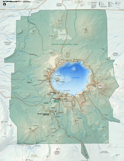
A map of Crater Lake national park. See the full-sized pdf version here.
The Color Ramps Version 2.0 collection of cartographic and geospatial gradients from GIS specialists, ESRI.
- Hypsometry: elevation and bathymetry
- Hill shading
- Geospatial events and processes
- Special cartographic effects
Derivative works permitted under the same licence. Disclaimer, patent prohibition, and US export restrictions apply. See details and XML record.