IBCSO

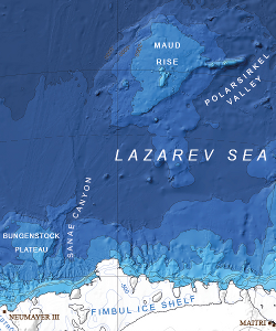
Detail of IBCSO version 1, 2013
The bathymetric scheme used by IBCSO: the International Bathymetric Chart of the Southern Ocean. The scheme was kindly provided by Jan Erik Arndt, Scientific Editor of IBCSO. The bath variant excludes the constant-white topography band, but is otherwise identical.
For further details on the IBCSO project see the paper by Arndt, J.E., Schenke, H.-W., Jakobsson, M., Nitsche, F.O., Buys, G., Goleby, B., Rebesco, M., Bohoyo, F., Hong, J., Black, J., Greku, R., Udintsev, G., Barrios, F., Reynoso-Peralta, W., Taisei, M., Wigley, R. The International Bathymetric Chart of the Southern Ocean (IBCSO) Version 1.0 — A new bathymetric compilation covering circum-Antarctic waters, to appear, Geophys. Res. Lett. (Available online.)
High resolution versions of the chart and the data used to produce it can be found on the IBCSO website.
Free to use: See details and XML record.

