Gradients and colour schemes in general

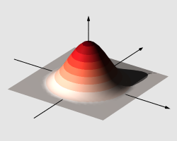
The radial basis function of R.M. Lewitt, rendered by POV-Ray using the Reds_09 colour scheme by Cynthia Brewer
- Cynthia A. Brewer, Professor at the Department of Geography of Pennsylvania State University has made studies in map design, colour theory applications in cartography, hypothesis generation in visualisation and choropleth classification for maps in series. She is an author of the wonderful ColorBrewer site whose schemes are available in cpt translation here.
- Shaded relief is a method for representing topography on maps in a natural, aesthetic, and intuitive manner. At the reliefshading.com site one can find rules and guidelines for the design and production of shaded relief, an overview of its history, examples produced by professional relief artists, technical tips, and much more. See also Tom Patterson's site, shadedrelief.com.
- Jim Mossman gives an interesting perspective on shading in cartography in a series of articles on his ShadeMax palettes: Parts 1, 2 and 3.
- The Department of Geography at the University of Oregon has an interesting site on data graphics, including several carefully chosen colour scales.
- The Dutch Interaction Designer, Kaeru, exhibits a selection of maps of public transport travel-times in the Netherlands on his Flickr page — the maps apply a colour gradient to discrete data points resulting in an attractive stippled effect which is both intuitive and explicit.
- The COLOURlovers site has a half-million five-colour discrete palettes, a few of which are available here. To download the palettes and convert to the cpt format, try this script.
- Adam Majewski's Color Gradient repo on GitHub carries a wealth of introductory material, illustrations and lots of up-to-date links.
See also the links page for software.